 Contact
 Comment faire ses achats
Livraison
Guide d'achat
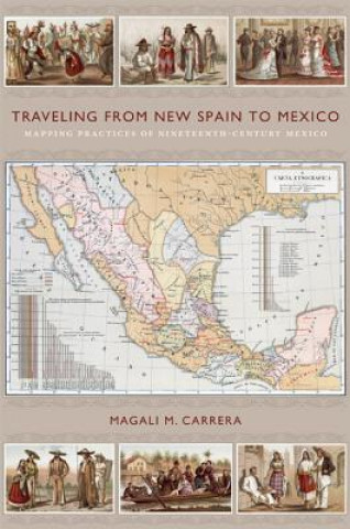
Traveling from New Spain to Mexico
 Anglais
 84 b
84 b
 common.delivery_to
Politique de retour sous 30 jours
Ceci pourrait également vous intéresser


Antonio Garcia Cubas's Carta general de la Republica Mexicana (1857), a widely acclaimed map of the independent Mexican nation-state, represented the country's geographic coordinates in precise detail. The respected geographer and cartographer made mapping Mexico his life's work. Combining insights from the history of cartography and visual culture studies, Magali M. Carrera explains how Garcia Cubas fabricated credible and inspiring nationalist visual narratives for a rising sovereign nation by linking old and new visual strategies. From the sixteenth century until the early nineteenth, Europeans had envisioned New Spain (colonial Mexico) in texts, maps, and other images. In the first decades of the 1800s, ideas about Mexican, rather than Spanish, national character and identity began to cohere in written and illustrated narratives produced by foreign travellers. During the nineteenth century, technologies and processes of visual reproduction expanded to include lithography, daguerreotype, and photography. New methods of displayosuch as albums, museums, exhibitions, and world fairsosignalled new ideas about spectatorship. Garcia Cubas participated in this emerging visual culture as he reconfigured geographic and cultural imagery culled from previous mapping practices and travel writing. In works such as the Atlas geografico (1858) and the Atlas pintoresco e historico (1885), he presented independent Mexico to Mexican citizens and the world.
À propos du livre
Anglais
Catégories
