 Contact
 Comment faire ses achats
Livraison
Guide d'achat
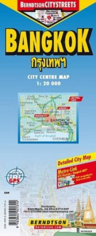
Bangkok
 Anglais
 25 b
25 b
 common.delivery_to
Politique de retour sous 30 jours
Ceci pourrait également vous intéresser


 /
Livre de poche
/
Livre de poche
 33.17
€
33.17
€

BerndtsonCITYSTREETS is a watersafe, durable, laminated and easy to fold city map. The BerndtsonCITYSTREETS features overview and detail maps with elaborate road and street network, points of interest, public facilities, hotels, shopping centers, markets and the MetroLINK (indicating the corresponding lines at stations in city maps). Further it includs a public transport map and a time zone map as well as useful statistics, weight and measurement conversion charts, climate charts with monthly temperatures, sunshine hours, precipitation and humidity. Special feature of the BerndtsonCITYSTREETS is a selection of the most popular POIs (points of interest) shown in a LocatorMAP and with a short text description including opening hours and useful web-sites. BerndtsonCITYSTREETS ist eine wasserabstoßende, langlebige, laminierte und leicht zu faltender Stadtplan. Die BerndtsonCITYSTREETS bietet Übersichts- und Detailkarten mit einem sorgfältig bearbeitetem Straßennetz, einer Auswahl an Sehenswürdigkeiten, öffentlichen Einrichtungen, Hotels, Shopping-Centern, Märkten und dem MetroLINK (es wird an Stationen die dazugehörigen Linien im Stadtplan angezeigt). Weiter enthalten ist eine Verkehrsnetzkarte und Zeitzonen-Karte sowie nützliche Statistiken, Gewichts- und Maßumwandlungen, Klimadiagramm mit monatlichen Temperaturanzeigen, Sonnenscheinstunden, Niederschlag und Luftfeuchigkeit. Besonderheit ist eine Auswahl der schönsten Sehenswürdigkeiten lokalisiert ein einer Lagekarte mit Kurzbeschreibung mit den Öffnungszeiten und ihren web-sites.
À propos du livre
Anglais
