 Contact
 How to shop
Delivery
Shopping guide
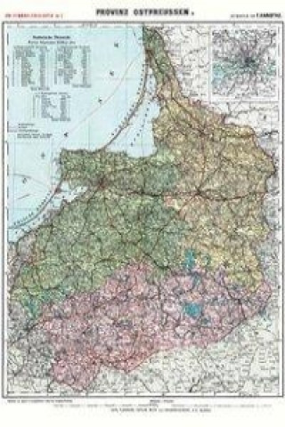
Historische Karte: Provinz Ostpreussen um 1910 (Plano)
 German
 50 b
50 b
 Delivery to Austria
30-day return policy
You might also be interested in


 /
Paperback
/
Paperback
 47.73
€
47.73
€
Außenformat (Breite x Höhe) 65 cm x 95 cm - Darstellungsgröße (Breite x Höhe) 63,7 x 87,7 cm.. Grenz-und flächenkolorierte Karte mit den Regierungsbezirk Königsberg; Regierungsbezirk Gumbinnen und Regierungsbezirk Allenstein. Reprint. --- [Lieferung in einer sehr stabilen Pappversandhülse - bis 72 cm lang - 250 g] Provinz Ostpreussen. Carl Flemmings Generalkarten No. 3. Carl Flemming Verlag Glogau, Buch- u. Kunstdruckerei, ohne Jahr (ca. 1910). Maßstab 1 : 475 000. Die Karte wurde aus 30 einzelnen Segmenten zusammengesetzt. Darstellung 21 % vergrößert zum Original.. Mit statistischer Übersicht aller Regierungsbezirke der Provinz Ostpreussen im oberen, linken Bereich und einer Extra-Karte von Königsberg und seiner Umgebung im oberen, rechten Bereich, im Maßstab 1: 150 000, um 21 % vergrößert.
About the book
German
